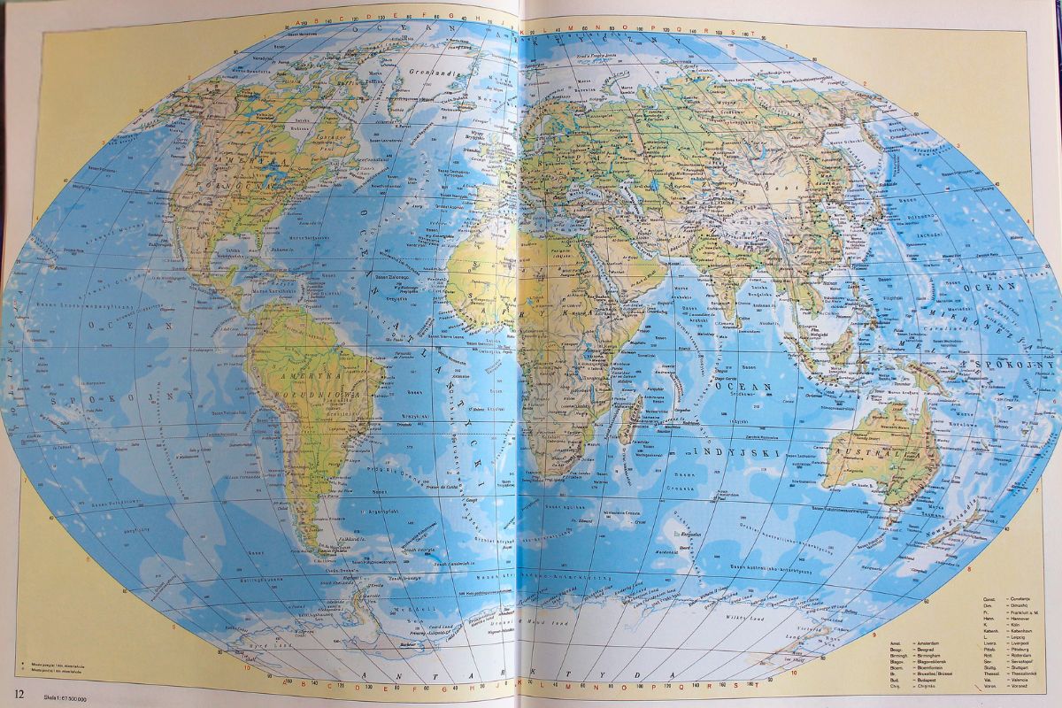
The United Nations approved a new world map adopting the Equal Earth projection to correct centuries of Mercator distortion, ensuring every continent is displayed at its true relative size for fair global representation in education, media, and diplomacy.
Adopted by the UN General Assembly on 4 September 2026, the resolution represents a major shift in how the world visualises geography. Led by African Union member states and the Bahamas, the “Correct the Map” resolution passed 164–1, urging governments, schools, and media institutions to transition away from the 450-year-old Mercator projection.
- The UN General Assembly adopted the “Correct the Map” resolution on 4 September 2026, encouraging (not mandating) a switch from the Mercator to the Equal Earth projection.
- The vote passed 164–1, with the United States the sole “no” vote and six countries abstaining, according to the Associated Press via NBC News.
- The Mercator projection, designed in 1569 for sea navigation, makes Africa appear roughly the same size as Greenland, when Africa is actually about 14 times larger.
- The campaign was driven by the advocacy groups Africa No Filter and Speak Up Africa, backed formally by the African Union in February 2026.
- The resolution is non-binding, so real-world change depends on adoption by schools, publishers, tech platforms and national mapping agencies over the coming years.
The “Correct the Map” resolution, led by African Union member states and the Bahamas, passed by 164 votes to one, with the United States opposed and six countries abstaining, according to Al Jazeera. It urges governments, schools, media and institutions to swap the 450-year-old Mercator projection for the Equal Earth projection, which shows continents at their true relative size. This matters now because it touches education, media literacy and the politics of representation all at once.
Why Now: The Mechanics Of A Map Distortion
To understand why this resolution landed in 2026, you need to understand the actual mechanics of the Mercator projection, not just the headline that “it’s wrong”. Gerardus Mercator designed his map in 1569 to solve one specific engineering problem: letting sailors draw a straight compass line across open ocean. To do that, the projection stretches the globe’s curved surface onto a flat rectangle by inflating land the further it sits from the equator.
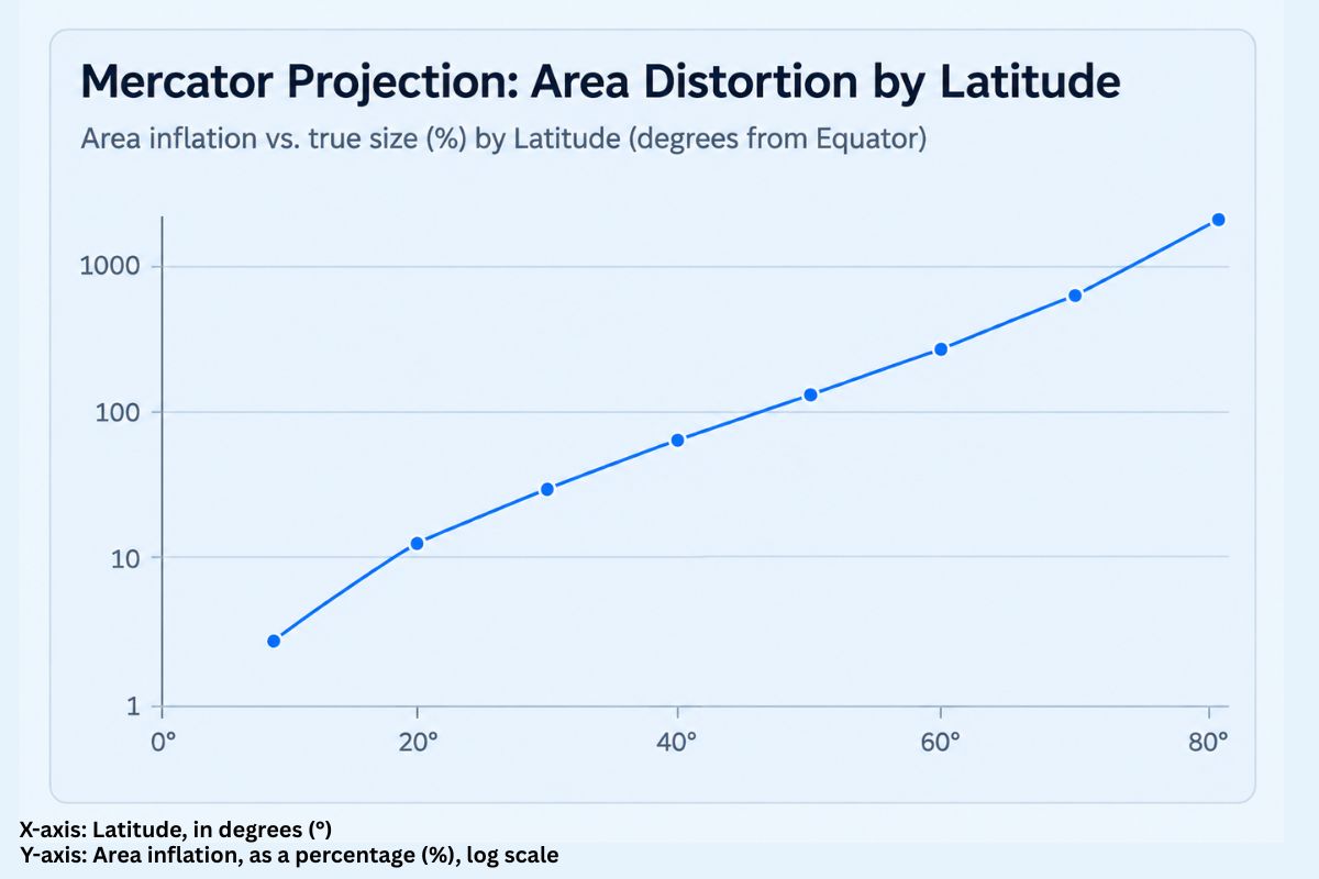
The trade-off is that shape is preserved locally, but area is not. As you move towards the poles, landmasses balloon in apparent size. That is why, on a standard Mercator map, Greenland looks comparable to Africa, when in reality Africa is around 14 times larger, a distortion widely cited by geographers and repeated in the UN debate, according to ABC News. Russia and Canada are similarly exaggerated, while equatorial regions — Africa, Latin America, South and Southeast Asia — are visually shrunk.
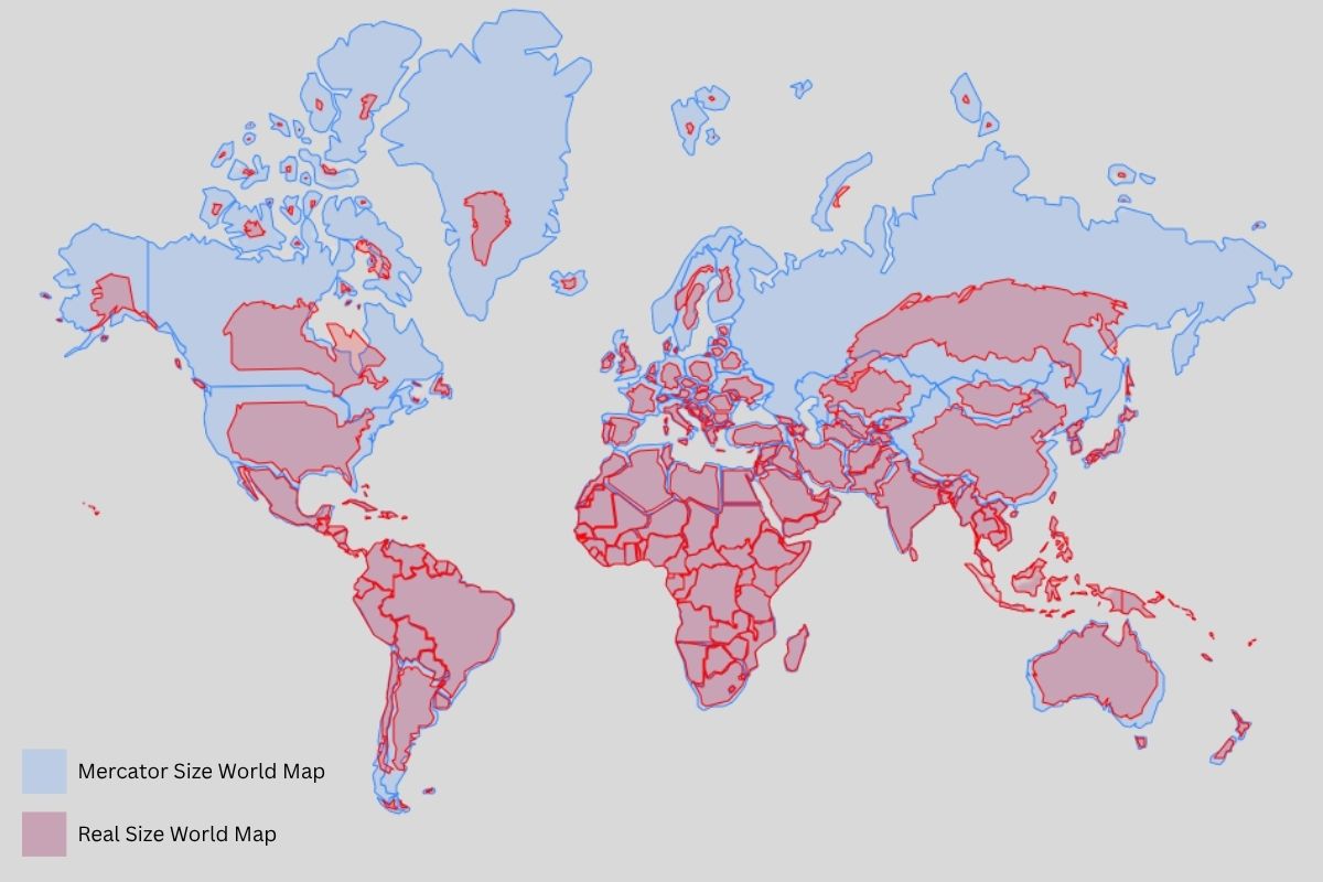
The resolution argues this is not a neutral technical quirk. Because the Mercator map became the default in schools, atlases, news graphics and digital platforms, it has shaped subconscious assumptions about which regions “matter” economically and politically.
Mercator Map Distortion vs. True Geographic Scale
| Landmass Comparison | Actual Area (sq km) | Mercator Visual Illusion | Equal Earth True Scale |
|---|---|---|---|
| Africa vs. Greenland | 30,370,000 vs. 2,166,000 | Appears roughly equal (~1 : 1 ratio) | Africa is ~14x larger |
| South America vs. Greenland | 17,840,000 vs. 2,166,000 | Greenland appears equal or larger | South America is ~8.2x larger |
| Brazil vs. Alaska | 8,515,000 vs. 1,717,000 | Alaska appears larger than Brazil | Brazil is ~5x larger |
| India vs. Scandinavia | 3,287,000 vs. 1,166,000 | Scandinavia appears larger than India | India is ~2.8x larger |
| Madagascar vs. United Kingdom | 587,000 vs. 242,900 | UK appears similar in size | Madagascar is ~2.4x larger |
Table Source: United Nations Environment Programme (UNEP) & CIA World Factbook Spatial Datasets.
Togo’s Foreign Minister, Robert Dussey, who led the resolution, told the Assembly that maps “guide education, nourish the imagination, and influence collective perceptions” and are “therefore never neutral”, as reported by ABC News. The structural shift, then, is not really about cartographic mathematics — it is about who gets to decide which distortions are acceptable, and for how long.
Key Players Behind The Resolution
Several distinct groups converged to make this resolution possible, each with a different role.
- Togo and the African Union member states — Togo formally introduced the draft resolution on behalf of the Group of African States at the UN, building on a decision the African Union Assembly had already taken in February 2026 to formally back the Equal Earth projection.
- The Bahamas — a co-sponsor representing small island and equatorial states, whose land area is similarly minimised under Mercator-style projections.
- Africa No Filter and Speak Up Africa — the two advocacy organisations that launched the “Correct the Map” campaign in April 2025, calling on the UN, World Bank and BBC to switch projections, and building the petition and coalition that fed into the AU decision.
- France — a co-sponsor of the resolution which announced its foreign ministry would abandon the Mercator map in its own publications, a notable move from a major Western power, according to Al Jazeera.
- The United States — the sole “no” vote was cast by the United States, with its UN representative characterising the debate as a distraction from more pressing international issues.
Each of these players brought different leverage: political sponsorship from African states, grassroots advocacy from civil society, and reputational signalling from a G7 government choosing to switch sides publicly.
The Adjacent Trend: Big Tech And The Quiet Shift Away From Flat Maps
What most coverage of this vote misses is that the technology industry got here first, quietly, years earlier — and for commercial rather than political reasons. In 2018, Google Maps introduced a 3D “globe mode” that automatically kicks in when a desktop user zooms out far enough, replacing the flat Web Mercator view with a rotating sphere on which “Greenland’s projection is no longer the size of Africa,” as Google Maps put it at the time, reported by Engadget. Google Maps posted on X, “With 3D Globe Mode on Google Maps desktop, Greenland’s projection is no longer the size of Africa.”
With 3D Globe Mode on Google Maps desktop, Greenland’s projection is no longer the size of Africa.
Just zoom all the way out at https://t.co/mIZTya01K3 😎🌍 pic.twitter.com/CIkkS7It8d
— Google Maps (@googlemaps) August 2, 2018
That change was never framed as a political statement, yet it addressed the identical distortion problem the UN resolution now names explicitly. It shows the convergence between two trends that rarely get discussed together: the politics of representation, driven by advocacy and diplomacy, and the technical modernisation of mapping software, driven by GIS vendors and consumer tech firms wanting more accurate, more “correct-looking” products.
Esri’s ArcGIS platform, one of the world’s leading professional mapping tools, had already added the Equal Earth projection as a built-in option from ArcGIS Pro 2.3 onward, and NASA’s Goddard Institute for Space Studies adopted it for its own scientific visualisations not long after it was published, according to Esri’s ArcGIS Pro documentation.
In other words, the professional cartography and Earth-science community had already been migrating away from Mercator-style thinking for scientific and design reasons, well before the UN vote gave it political cover.
Also Read: India’s New Space Race: Inside The Space Startup Boom In Satellites, Drones And Defence Tech
Funding And Adoption Trends
There is no single “market” for map projections in the way there is for, say, cloud computing, so there are no venture funding rounds to report here. What can be tracked, however, is the pace of institutional adoption of the Equal Earth projection since its creation — a reasonable proxy for momentum.
The projection itself was developed in 2018 by cartographers Bojan Šavrič, Tom Patterson and Bernhard Jenny, and published in the International Journal of Geographical Information Science, where it became one of the journal’s most-read papers with more than 12,000 views, according to Esri’s ArcUser magazine.
From there, adoption spread in stages: first into professional GIS software from 2018–2019, then into NASA visualisations, then into advocacy and education circles following Boston Public Schools’ earlier switch to the (visually different) Gall-Peters equal-area projection in 2017 — a decision that directly inspired Equal Earth’s creators to design a more aesthetically balanced alternative.
Major World Map Projections Compared
| Map Projection | Year Introduced | Map Category | Primary Advantage | Key Limitation / Distortion |
|---|---|---|---|---|
| Mercator | 1569 | Conformal (Preserves Angles) | Maintains straight compass lines for maritime navigation | Severely inflates landmasses near the poles (e.g., Greenland, Europe) |
| Gall-Peters | 1855 / 1973 | Equal-Area (Preserves Relative Size) | Displays accurate relative land areas | Distorts shapes by stretching landmasses vertically near the equator |
| Robinson | 1963 | Compromise (Balances Area & Shape) | Visually appealing balance for world reference maps | Slightly distorts both shape and area; not a true equal-area projection |
| Winkel Tripel | 1921 | Compromise (Minimizes 3 Distortions) | Low overall distortion in area, direction, and distance | Poles remain slightly enlarged; not a true equal-area projection |
| Equal Earth | 2018 | Equal-Area (Preserves Relative Size) | Maintains 100% true relative land sizes with natural-looking continental shapes | Minor shape distortion along the outer eastern and western map edges |
Table Source: International Cartographic Association (ICA) & International Journal of Geographical Information Science.
The “Correct the Map” campaign, launched in April 2025, added formal political weight, culminating in the African Union’s endorsement in February 2026 and the UN vote in September 2026.
Institutional And Government Support Mechanisms
Unlike a funding programme or subsidy scheme, the “support mechanism” here is diplomatic and reputational rather than financial. The resolution is non-binding, meaning it carries no legal obligation and no enforcement budget. Its power comes from three channels instead:
- Multilateral endorsement — a 164-country vote gives the campaign moral authority that a single advocacy group could never generate alone.
- Government-level signalling — France’s public commitment to drop Mercator from its own foreign ministry materials sets a precedent other governments may follow.
- Sector-specific pledges — the original Correct the Map campaign explicitly targeted the UN, World Bank and BBC as institutions whose adoption would ripple outward into education and media, according to Africa No Filter.
In practice, the resolution functions as a form of soft-power infrastructure: it does not fund new textbooks or redesign the BBC’s weather graphics, but it gives ministries of education and public broadcasters political cover to make that switch without appearing to take an eccentric or unilateral stance.
Challenges And Risks
The resolution’s biggest structural weakness is that it has no teeth. It “encourages” rather than requires member states to change their maps, so uptake will vary hugely by country and sector. Several other risks are worth flagging honestly:
- Cost and logistics — replacing printed atlases, classroom wall maps and legacy government publications is not free, and smaller or lower-income education systems may be slow to prioritise it.
- Navigation trade-offs — Mercator’s core utility (constant compass bearings) still matters for maritime and some aviation navigation, so it is unlikely to disappear from specialist use entirely.
- Political backlash — the US delegation’s objection, framed as viewing the debate as a distraction from more urgent global issues, signals that some governments may treat this as a symbolic culture-war flashpoint rather than a technical correction, a framing risk the campaign will need to manage.
- Measurement problem — because compliance is voluntary and unmonitored, it will be difficult to verify in a few years’ time how many schools, broadcasters or agencies actually switched, versus how many simply endorsed the principle.
Global And Comparative Context
Placed against other UN cartographic and standards efforts, this vote is unusually high-profile. The UN Committee of Experts on Global Geospatial Information Management (UN-GGIM) ordinarily handles far more technical geospatial standard-setting with little public attention; this campaign instead escalated the issue to the General Assembly floor, turning a projection choice into a full multilateral vote — itself a signal of how seriously African states wanted the issue treated.
Internationally, reactions split along familiar lines. France, the UK and most of the Global South-aligned bloc backed the resolution. The US stood alone in opposition. Six countries — Serbia, Estonia, Georgia, Lithuania, Moldova and Ukraine — abstained, according to the Associated Press, a bloc worth noting because several of these states have their own long-running disputes about how their territory is represented on maps, which may explain their caution about setting new cartographic precedents.
Where This Goes Next
Because the resolution is a statement of intent rather than a mandate, the next 12–24 months will be the real test of its impact. Watch for three signals: whether major publishers and cartographic atlas producers update new print runs; whether national curricula (beyond the early movers like Boston Public Schools) formally specify Equal Earth or an equivalent equal-area projection; and whether large digital platforms extend globe-style, distortion-free views from desktop into default mobile experiences, which remains the biggest gap given how most people now view maps on phones.
Momentum built from a 2025 grassroots petition to a 164-country UN vote within roughly 18 months suggests the coalition behind Correct the Map is well organised and likely to keep pushing institutions named in its original charter — the World Bank and BBC among them — for the next visible commitments.
The Takeaway
The UN’s adoption of a new world map is less about redrawing borders and more about redrawing assumptions. It formalises, at the highest diplomatic level, an argument that cartographers, educators and African advocacy groups have been making for years: that a 16th-century navigational tool has quietly distorted how billions of people picture the relative scale and importance of entire continents. The resolution carries no enforcement mechanism, so its real test will play out slowly, in classrooms, atlases, broadcasters and mapping apps over the coming years, rather than overnight.
Frequently Asked Questions
What Exactly Did The UN Vote For?
The UN General Assembly adopted a resolution encouraging member states and institutions to replace the Mercator map projection with the Equal Earth projection, which more accurately represents the true relative size of continents.
Is The New World Map Now Mandatory?
No. The resolution is non-binding. It “urges” and “encourages” adoption rather than requiring it, so change will happen unevenly depending on national and institutional decisions.
Why Does Africa Look Smaller On The Old Map?
The Mercator projection, created in 1569 for sea navigation, distorts area by inflating landmasses further from the equator. This makes Africa appear roughly the size of Greenland, when Africa’s true area is around 14 times larger.
Who Created The Equal Earth Projection?
Cartographers Bojan Šavrič, Tom Patterson and Bernhard Jenny developed it in 2018 as a more visually balanced alternative to earlier equal-area projections such as Gall-Peters.
Which Country Voted Against The Resolution?
The United States was the only country to vote against the resolution; 164 countries voted in favour and six abstained.
Sources & References
- Associated Press / NBC News: UN General Assembly endorses new world map
- Al Jazeera: UN votes to adopt new world map that reflects Africa’s true size
- ABC News: Africa and Australia bigger, US smaller as UN adopts new world map
- Esri ArcGIS Pro: Equal Earth projection documentation
Disclaimer: This article is published strictly for general informational and educational purposes concerning global diplomatic and cartographic developments, and is not intended for commercial promotion. While information has been compiled from reputable international news agencies and institutional reporting, details may evolve over time. Readers should independently verify facts and seek official documentation or qualified professional advice before acting upon any projections or data cited herein.